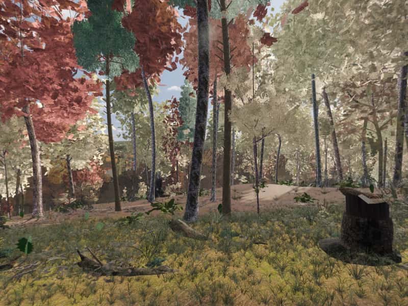
 Look around in 360
Campsite 37
974 ft east-facing ridge crest
Site 37 is one of the primitive, first-come campsites scattered through Green Ridge State Forest in western Maryland. It sits at 974 ft on an east-facing ridge crest, with White Sulphur Pond 0.8 mi northeast. The drive in is rated “High clearance”.
- Booking
- None. Sites are first come, first served.
- Fee
- $10 a night for a standard site, $20 for a group site, paid at headquarters. Maryland DNR.
- Check in
- Sign the sheet at headquarters when you arrive, then go to the site.
- Is it free tonight?
- This page cannot know. The app shows what the sign-up sheet last showed, with the photo's age.
Ridge-top, four-wheel drive only, quiet, secluded.
- Modeled974 ft, east-facing ridge crest.
- ModeledHigh-clearance track, 11.1 mi and 30 min from HQ, 3.6 mi of it unpaved, 26% grade on the way. The pitch sits 144 ft from the road.
- ModeledWhite Sulphur Pond 0.8 mi northeast.
- ModeledOut of earshot of the range, the interstate and the freight line.
- CommunityRoom for a pop-up, secluded.
- CommunityDescribed by campers, not yet photographed for Greenridge. Everything else here is modeled.
Modeled from USGS elevation, OpenStreetMap roads and the sun Community reported by campers
Hours of direct sun
The tallest ground on this site's horizon stands 4.5° above level, to the west.
On the March equinox direct sun reaches the pitch at 7:34 am and leaves it at 6:58 pm: 11 h 26 m of it, against 12 h 12 m of daylight on an open horizon.
| Date | First light | Last light | Direct sun | Open horizon |
|---|---|---|---|---|
| 20 March | 7:34 am | 6:58 pm | 11 h 26 m | 12 h 12 m |
| 21 June | 5:58 am | 8:18 pm | 14 h 22 m | 15 h 2 m |
| 21 December | 7:56 am | 4:40 pm | 8 h 46 m | 9 h 26 m |
The ground
The elevation model puts the pitch at 974 ft, on a ridge crest tilted about 8.2° to the east.
Within the 1.2 km square sampled around it, the site stands 202 ft above the lowest ground in that square, which lies 0.5 mi northeast.
The nearest mapped water is White Sulphur Pond, 0.8 mi northeast.
Nearby sites
- Site 36 2387 ft away
Upper slope, four-wheel drive only, quiet, secluded.
- Site 38 0.7 mi away
Upper slope, easy in, quiet, secluded.
- Site 32 0.8 mi away
Valley-floor, by a creek, easy in, quiet.
- Site 35 0.8 mi away
Upper slope, easy in, quiet.
How to choose between them · All 100 sites
On these shortlists: Quiet · Sunny · Secluded · All shortlists
How campers describe it
- Rough access
- Pop-up camper OK
- Secluded
Limited privacy; rough access road.
Field note from campers who have stayed here. Not an official description, and conditions change.
When the ridge takes the sun
- 20 MarchSun off the pitch at 6:58 pm, 30 minutes before sunset
- 21 JuneSun off the pitch at 8:18 pm, 30 minutes before sunset
- 22 OctoberSun off the pitch at 6:02 pm, 26 minutes before sunset
- 21 DecemberSun off the pitch at 4:40 pm, 16 minutes before sunset
For tonight, with the moon, darkness and the overnight low, open Site 37 in the app.
Provenance
Most of this page is computed from public data; the lines marked Community come from campers. The computed data was last rebuilt from its sources on 28 September 2026.
- Elevation, landform, slope, aspect, contours, the horizon profile and the steepest grade on the approach come from the USGS 3D Elevation Program (3DEP), read from its elevation tiles.
- Roads and watercourses come from OpenStreetMap contributors, licensed ODbL, as mapped at that rebuild. A road can wash out or close after it.
- Sun times are when the sun clears that measured skyline, computed with the NOAA Solar Calculator equations. They are for 2026 and shift by a minute or two from year to year.
- The pin comes from the Maryland Department of Natural Resources campsite GIS layer.
- Evenings here are the same sun times, on four dates of the year: when the sun drops behind this pitch's measured skyline, against the open-horizon sunset.
- The modeled view and the 360 are rendered from a 3D model of the forest, from the pitch, through a whole day in each of five seasons. The ground is the same elevation data plus lidar. Tree heights come from lidar; the species mix and tree form come from US Forest Service inventory plots in Allegany County, so no tree here was surveyed individually. The tent, table and fire ring are the same stand-ins at every site. When a photograph from the site, ours or one a camper sends, shows the model is wrong about where the pitch is or what the ground is like, the model is corrected and the 360 is rendered again. How the 360 is made.
- Character tags and field notes come from campers. They are judgements rather than measurements.
- Availability is not on this page because nothing publishes it. The app shows what the last photograph of the sign-up sheet said, and how old that photograph is.
Greenridge is independent and is not affiliated with the Maryland Department of Natural Resources or any government agency. The forest's own rules apply.