The campsite map: all 100 sites by road
Every numbered campsite as a pin on the forest roads, with headquarters, Bonds Landing and the overlooks. Tap a pin for that site’s page: its ground, its sun, and the drive in. The map shows where the sites are, never whether they are free; for that there is only the clipboard at headquarters.
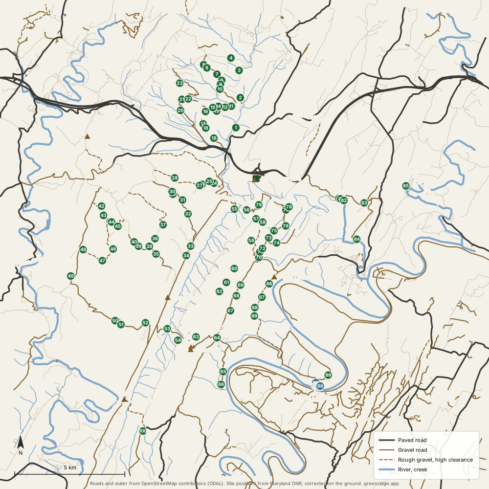
By road
-
Bonds Landing, on the Potomac
9 sites. The drive in is rated “rough” or “gravel” on the site pages.
-
Dughill Road
8 sites. The drive in is rated “gravel” or “rough” on the site pages.
-
Mertens Avenue
7 sites. The drive in is rated “gravel” on the site pages.
-
Big Ridge Road
6 sites. The drive in is rated “gravel” or “rough” on the site pages.
-
Oldtown Orleans Road
6 sites. The drive in is rated “gravel” on the site pages.
-
Double Pine Road
5 sites. The drive in is rated “gravel” on the site pages.
-
Sugar Bottom Road
5 sites. The drive in is rated “rough” on the site pages.
-
Twigg Road
5 sites. The drive in is rated “rough” on the site pages.
-
Carrol Road
4 sites. The drive in is rated “rough” on the site pages.
-
Jacobs Road
4 sites. The drive in is rated “gravel” on the site pages.
-
Mountain Road
4 sites. The drive in is rated “rough” or “gravel” on the site pages.
-
Carpenter Road
3 sites. The drive in is rated “rough” on the site pages.
-
Fifteen Mile Creek Road Southeast
3 sites. The drive in is rated “gravel” on the site pages.
-
East Valley Road
2 sites. The drive in is rated “gravel” or “rough” on the site pages.
-
Fifteen Mile Creek Road
2 sites. The drive in is rated “gravel” on the site pages.
-
May Road
2 sites. The drive in is rated “rough” on the site pages.
-
Outdoor Club Road
2 sites. The drive in is rated “rough” on the site pages.
-
Stafford Trail Road
2 sites. The drive in is rated “rough” on the site pages.
-
Cliff Road
1 site. The drive in is rated “rough” on the site pages.
-
Frank Davis Road
1 site. The drive in is rated “rough” on the site pages.
-
Green Ridge Road
1 site. The drive in is rated “gravel” on the site pages.
-
Howard Road
1 site. The drive in is rated “gravel” on the site pages.
-
Kasecamp Road
1 site. The drive in is rated “rough” on the site pages.
-
Keifer Road
1 site. The drive in is rated “gravel” on the site pages.
-
Old Cumberland Road Northeast
1 site. The drive in is rated “gravel” on the site pages.
-
Treasure Road
1 site. The drive in is rated “gravel” on the site pages.
-
Wallizer Road
1 site. The drive in is rated “gravel” on the site pages.
-
Yonkers Bottom Road
1 site. The drive in is rated “gravel” on the site pages.
-
Unnamed forest road
10 sites. The drive in is rated “gravel” or “rough” or “high clearance” on the site pages.
- Booking
- None. Sites are first come, first served.
- Fee
- $10 a night for a standard site, $20 for a group site, paid at headquarters. Maryland DNR.
- Check in
- Sign the sheet at headquarters when you arrive, then go to the site.
- Is it free tonight?
- This page cannot know. The app shows what the sign-up sheet last showed, with the photo's age.