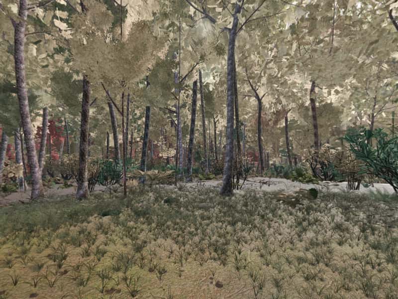
 Look around in 360
Campsite 17
1,003 ft ridge crest
Site 17 is one of the primitive, first-come campsites scattered through Green Ridge State Forest in western Maryland. It sits at 1,003 ft on a ridge crest, with running water 0.2 mi west. The drive in is rated “Gravel road”.
- Booking
- None. Sites are first come, first served.
- Fee
- $10 a night for a standard site, $20 for a group site, paid at headquarters. Maryland DNR.
- Check in
- Sign the sheet at headquarters when you arrive, then go to the site.
- Is it free tonight?
- This page cannot know. The app shows what the sign-up sheet last showed, with the photo's age.
Ridge-top, by a creek, easy in, some noise.
- Modeled1,003 ft, ridge crest.
- ModeledGravel road, 4.6 mi and 12 min from HQ, 1.1 mi of it unpaved, 15% grade on the way.
- ModeledRunning water 1184 ft west.
- ModeledWithin earshot of Interstate 68 (0.8 mi away) and the shooting range (1.4 mi away).
- ModeledModeled only: nobody has photographed or described this pitch for Greenridge yet.
Modeled from USGS elevation, OpenStreetMap roads and the sun Community reported by campers
Hours of direct sun
The tallest ground on this site's horizon stands 3.2° above level, to the northwest.
On the March equinox direct sun reaches the pitch at 7:30 am and leaves it at 7:10 pm: 11 h 42 m of it, against 12 h 12 m of daylight on an open horizon.
| Date | First light | Last light | Direct sun | Open horizon |
|---|---|---|---|---|
| 20 March | 7:30 am | 7:10 pm | 11 h 42 m | 12 h 12 m |
| 21 June | 5:56 am | 8:26 pm | 14 h 32 m | 15 h 2 m |
| 21 December | 7:44 am | 4:42 pm | 9 h | 9 h 26 m |
The ground
The elevation model puts the pitch at 1,003 ft, on a ridge crest. At 1° the ground is level enough that it does not face anywhere in particular.
Within the 1.2 km square sampled around it, the site stands 234 ft above the lowest ground in that square, which lies 0.4 mi south.
The nearest mapped water is an unnamed run 0.2 mi west. OpenStreetMap maps the channel but has no name for it. Treat any water from it before drinking.
Nearby sites
- Site 18 731 ft away
Ridge-top, by a creek, easy in, some noise.
- Site 16 1862 ft away
Ridge-top, by a creek, easy in, some noise.
- Site 19 2659 ft away
Ridge-top, by a creek, easy in, some noise.
- Site 13 2755 ft away
Ridge-top, by a creek, rough in, some noise.
How to choose between them · All 100 sites
On these shortlists: Easy access · Open sky · Sunny · Near HQ · All shortlists
When the ridge takes the sun
- 20 MarchSun off the pitch at 7:10 pm, 18 minutes before sunset
- 21 JuneSun off the pitch at 8:26 pm, 22 minutes before sunset
- 22 OctoberSun off the pitch at 6:10 pm, 18 minutes before sunset
- 21 DecemberSun off the pitch at 4:42 pm, 14 minutes before sunset
For tonight, with the moon, darkness and the overnight low, open Site 17 in the app.
In August 1932 the State recorded its deed for 11,616 acres of abandoned orchard land, the start of what is now a 47,560-acre forest.
A forest from the wreckage · 1931 → today · about 0.9 mi from this site, at Superintendent's Residence, Green Ridge State Forest
By the end of the 1920s most of the failed orchard land belonged to the Allegany Orchards Corporation, and the Depression ended any revival. The land was cutover, burned, and planted with failing orchards. In 1931 the state forestry service under State Forester Fred W. Besley took an interest in it, and in August 1932 the deed to the State for 11,616 acres was recorded. DNR's own publications give other figures for the first purchase, about 2,000 acres in 1931 and about 14,400 acres; the 1932 deed is the only figure tied to a record. The first state work on the land was done by the Civilian Conservation Corps from 1933, chiefly fire control. The State kept adding land. By DNR's 2019 plan the forest covers 47,560 acres, the second-largest state forest in Maryland and about 12 percent of all the land DNR manages. Most of it is the even-aged oak that grew up after the clearing.
What is left to see: The oak woods themselves: whole hillsides of trees of about the same size, dating from the same years of abandonment.
Sources (4)
- MHT survey AL-I-A-055, Green Ridge Camp CCC Headquarters Building, CCC Camp S-53 (Paula S. Reed & Edie Wallace, 2009; cites Mash, The Land of the Living)
- Maryland DNR, Sustainable Forest Management Plan for Green Ridge State Forest (2019), §1.1, §2.4.3, §2.11–2.14, §3.2, §5.12, §9.2
- Francis "Champ" Zumbrun, "Point Lookout in Green Ridge State Forest", DNR Centennial Notes
- Maryland DNR, Green Ridge State Forest Driving Tour (PDF)
The forest's first commercial harvest after the State bought it was a 200-acre clear-cut in 1969, and the stand, thinned in 2010, is a stop on the driving tour.
Managing the regrown forest, 1932 to now · 1932–today · about 0.9 mi from this site, at Superintendent's Residence, Green Ridge State Forest
When the State took the deed for 11,616 acres in 1932, the land was cutover, burned and planted with failing orchards. The Civilian Conservation Corps spent the 1930s on fire control, roads and trails, and the forest grew back as even-aged oak. As it grew, hunters and the local wood industry used more of it. The first commercial regeneration harvest after state purchase was a 200-acre clear-cut in 1969 on Oldtown Orleans Road; that stand was thinned in 2010. Forest managers stayed long: John Mash ran the forest from 1975 to 1988, and Francis 'Champ' Zumbrun from 1978 to 2009. In 2007 a stand on Tower Road was cut by variable retention, taking most trees over two inches but leaving islands of old trees, and DNR maps about 250 acres of mature forest a year into this rotation, though not all of it is cut. The State has also set land aside. Under the Wildlands Act of 1971 three wildlands were designated here: Maple Run (2,760 acres), Deep Run (1,260) and Potomac Bends (2,034). DNR counts 14 small old-growth remnants, about 198 acres. The forest was first evaluated for dual certification under the Forest Stewardship Council and Sustainable Forestry Initiative standards in spring 2011 and is audited every year. The hiking trail system, about 40 miles, became a National Recreation Trail on 3 June 2005; the 12-mile mountain bike loop and the Maryland section of the Great Eastern Trail came after.
What is left to see: The 2007 variable retention harvest on Tower Road (driving tour mile 6) and the thinned 1969 stand by the Brinkman-Rine Cemetery (mile 19.2). The old-growth remnant on Mertens Avenue at mile 19.9.
Sources (4)
- Maryland DNR, Sustainable Forest Management Plan for Green Ridge State Forest (2019), §1.1, §2.4.3, §2.11–2.14, §3.2, §5.12, §9.2
- Maryland DNR, Green Ridge State Forest Driving Tour (PDF)
- MHT survey AL-I-A-055, Green Ridge Camp CCC Headquarters Building, CCC Camp S-53 (Paula S. Reed & Edie Wallace, 2009; cites Mash, The Land of the Living)
- Mountain Discoveries, "Land of the Living" (book notice, 2003)
Provenance
Most of this page is computed from public data; the lines marked Community come from campers. The computed data was last rebuilt from its sources on 28 September 2026.
- Elevation, landform, slope, aspect, contours, the horizon profile and the steepest grade on the approach come from the USGS 3D Elevation Program (3DEP), read from its elevation tiles.
- Roads and watercourses come from OpenStreetMap contributors, licensed ODbL, as mapped at that rebuild. A road can wash out or close after it.
- Sun times are when the sun clears that measured skyline, computed with the NOAA Solar Calculator equations. They are for 2026 and shift by a minute or two from year to year.
- The pin comes from the Maryland Department of Natural Resources campsite GIS layer.
- Evenings here are the same sun times, on four dates of the year: when the sun drops behind this pitch's measured skyline, against the open-horizon sunset.
- What happened near here comes from published history: Maryland Historical Trust survey forms, Maryland DNR, the National Park Service and the C&O Canal's historians, and the records themselves. Each story lists its own sources; a story appears only when one of its catalogued places is within about two miles, and the distance is measured, not estimated. All the history sources.
- The modeled view and the 360 are rendered from a 3D model of the forest, from the pitch, through a whole day in each of five seasons. The ground is the same elevation data plus lidar. Tree heights come from lidar; the species mix and tree form come from US Forest Service inventory plots in Allegany County, so no tree here was surveyed individually. The tent, table and fire ring are the same stand-ins at every site. When a photograph from the site, ours or one a camper sends, shows the model is wrong about where the pitch is or what the ground is like, the model is corrected and the 360 is rendered again. How the 360 is made.
- Character tags and field notes come from campers. They are judgements rather than measurements.
- Availability is not on this page because nothing publishes it. The app shows what the last photograph of the sign-up sheet said, and how old that photograph is.
Greenridge is independent and is not affiliated with the Maryland Department of Natural Resources or any government agency. The forest's own rules apply.