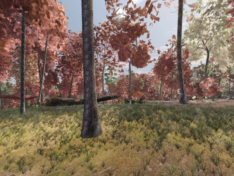
 Look around in 360
Campsite 58
1,545 ft north-facing ridge crest
Site 58 is one of the primitive, first-come campsites scattered through Green Ridge State Forest in western Maryland. It sits at 1,545 ft on a north-facing ridge crest, with running water 0.2 mi southeast. It is a walk-in: the drive to the parking is rated “Rough road”, and the pitch is 398 m further on foot.
- Booking
- None. Sites are first come, first served.
- Fee
- $10 a night for a standard site, $20 for a group site, paid at headquarters. Maryland DNR.
- Check in
- Sign the sheet at headquarters when you arrive, then go to the site.
- Is it free tonight?
- This page cannot know. The app shows what the sign-up sheet last showed, with the photo's age.
Ridge-top, by a creek, rough in, quiet.
- Modeled1,545 ft, north-facing ridge crest.
- ModeledRough road, 5.0 mi and 22 min from HQ, 3.6 mi of it unpaved to Stafford Trail Road. Walk-in from there: 1306 ft, about 8 min with gear.
- ModeledRunning water 1093 ft southeast.
- ModeledOut of earshot of the range, the interstate and the freight line.
- CommunityWalk-in.
- CommunityDescribed by campers, not yet photographed for Greenridge. Everything else here is modeled.
Modeled from USGS elevation, OpenStreetMap roads and the sun Community reported by campers
Hours of direct sun
The tallest ground on this site's horizon stands 2.9° above level, to the south.
On the March equinox direct sun reaches the pitch at 7:20 am and leaves it at 7:24 pm: 12 h 6 m of it, against 12 h 12 m of daylight on an open horizon.
| Date | First light | Last light | Direct sun | Open horizon |
|---|---|---|---|---|
| 20 March | 7:20 am | 7:24 pm | 12 h 6 m | 12 h 12 m |
| 21 June | 5:48 am | 8:40 pm | 14 h 54 m | 15 h 2 m |
| 21 December | 7:38 am | 4:50 pm | 9 h 14 m | 9 h 26 m |
The ground
The elevation model puts the pitch at 1,545 ft, on a ridge crest tilted about 3.6° to the north.
Within the 1.2 km square sampled around it, the site stands 652 ft above the lowest ground in that square, which lies 0.4 mi east.
The nearest mapped water is an unnamed run 0.2 mi southeast. OpenStreetMap maps the channel but has no name for it. Treat any water from it before drinking.
Nearby sites
- Site 57 1103 ft away
Hillside, by a creek, rough in, quiet.
- Site 75 2115 ft away
Flat shelf, by a creek, rough in, quiet.
- Site 73 2499 ft away
Hollow, by a creek, easy in, quiet, secluded.
- Site 79 2634 ft away
Flat shelf, by a creek, rough in, some noise.
How to choose between them · All 100 sites
On these shortlists: Quiet · Open sky · Sunny · All shortlists
How campers describe it
- Walk-in
When the ridge takes the sun
- 20 MarchSun off the pitch at 7:24 pm, close to sunset
- 21 JuneSun off the pitch at 8:40 pm, close to sunset
- 22 OctoberSun off the pitch at 6:22 pm, close to sunset
- 21 DecemberSun off the pitch at 4:50 pm, close to sunset
For tonight, with the moon, darkness and the overnight low, open Site 58 in the app.
DNR's plan counts hunters as the largest group of people who use Green Ridge, and calls it one of the most popular public hunting areas in Maryland.
A hunter's forest · 1916–today · about 1.5 mi from this site, at Hunter's Cabin
Hunters are the largest group of people who use Green Ridge, and DNR's plan calls it one of the most popular public hunting areas in Maryland. Maryland began licensing hunters in 1916. As printed in DNR's 2019 plan, licence sales peaked at about 180,000 in the early 1970s and later fell to about 135,000. The hunting camps came early. A 1920s board-and-batten cabin on Oldtown Road, surveyed in the 1970s, is one of many such vacation and hunting cabins once scattered through these mountains, and a nineteenth-century log farmhouse on Appel Road was by then lived in only in hunting season. In 1975 the owner of the Little Orleans store told the Cumberland News that his busiest week of the year was deer season. In the 1990–91 seasons hunters reported 1,360 deer taken in the forest, and DNR estimated a herd of about 3,590, or 35 to 45 deer per square mile. In October 2004 Maryland held its first black bear season in 51 years. Most of the forest is open to hunting and trapping in season; target shooting is allowed only at the forest's shooting range, which was paid for with hunting licence fees and is used by permit from headquarters.
What is left to see: The forest's shooting range on US 40 Scenic, near the end of the driving tour; permits are sold only at headquarters. Check Maryland's current hunting season dates before walking the woods in autumn.
Sources (4)
- Maryland DNR, Sustainable Forest Management Plan for Green Ridge State Forest (2019), §1.1, §2.4.3, §2.11–2.14, §3.2, §5.12, §9.2
- Maryland DNR, Green Ridge State Forest Driving Tour (PDF)
- MHT survey AL-I-A-043, Little Orleans Grocery (Bill's Place), incl. Cumberland News, 5 Jun 1975
- MHT survey AL-I-A-056, Hunter's Cabin; AL-I-A-042, McKnight Log House — via repo summaries
On 2 August 1864 a Confederate gun at Oldtown put a shot through the boiler of a Union iron-clad train, and the river crossing's defenders surrendered.
The Civil War on the upper Potomac · 1861–1864 · about 1.5 mi from this site, at Point Lookout
The Potomac here was a border, with the canal and the Baltimore and Ohio Railroad running along it. In the winter of 1862, according to the Morgan County historical society, Brigadier General Frederick W. Lander held the river line with about 16,000 Union troops quartered at Camp Chase near Paw Paw; Lander died there of pneumonia on 2 March 1862. On 4 October 1862 Confederate troops under John Imboden attacked Company K of the 54th Pennsylvania at the mouth of the Little Cacapon, and their cavalry captured Company B, camped about 500 yards from the Paw Paw Tunnel. In June 1863 raiders under Lieutenant Colonel Elijah White cut the canal just below Lock 67 and between Locks 71 and 72. In the summer of 1864 raiders captured 14 canal boats near Lock 68, most of them loaded with coal, and set them on fire, with the pivot bridge over the lock. Union troops stationed at Little Orleans are said to have used Point Lookout and the nearby ridges to watch the canal, the railroad and the river crossings, and DNR gives that as the likely origin of the overlook's name. In Flintstone, Confederate troops looted the Wilson family's store, which still stood on Old Route 40 when it was surveyed. On 2 August 1864, at the forest's southwest edge, Confederate cavalry under Brigadier General John McCausland, retreating after burning Chambersburg, Pennsylvania, reached the river at Oldtown. Colonel Israel Stough held the crossing with part of the 153rd Ohio, a blockhouse and an iron-clad train. A Confederate gun put a shot through the train's boiler, and Stough, outnumbered, surrendered on condition that his men be paroled at once. In his report, General Kelley gave Confederate losses of 20 to 25 killed and 40 to 50 wounded, and Union losses of 2 killed and 3 wounded.
What is left to see: Point Lookout on Carroll Road (driving tour mile 16). Oldtown is at the forest's southwest corner on MD 51; the crossing and the Green Spring side are partly private. The Flintstone store is a private building; see it from the road.
“Colonel Stough, with the small command now left him, assisted by the iron-clad cars, commanded by Captain Petrie... continued to defend the crossing until the enemy succeeded in disabling the iron-clads, by a shot through the boilers”
Report of Bvt. Maj. Gen. B. F. Kelley, Official Records (transcribed at korns.org)
Sources (8)
- Francis "Champ" Zumbrun, "Point Lookout in Green Ridge State Forest", DNR Centennial Notes
- Maryland DNR, Green Ridge State Forest Driving Tour (PDF)
- MHT survey AL-I-C-058, Point Lookout (Preservation Associates, 1979)
- Wikipedia, Paw Paw, West Virginia (16,000 Union troops at Camp Chase under Lander; cites Morgan County Historical and Genealogical Society, 1981)
- Wikipedia, Battle of Old Town (U.S. Civil War 1864 Valley Campaign)
- Report of Bvt. Maj. Gen. B. F. Kelley on the action of 2 Aug 1864 (Official Records transcription, korns.org)
- MHT survey AL-II-A-044, Helmick's Grocery Store (looted by Confederate troops) — via repo summary
- Bedell et al., River and Mountain, War and Peace (NPS, 2011), pp. 74–75 (Imboden 1862; White 1863; Lock 68, 1864; citing Unrau 2007)
Provenance
Most of this page is computed from public data; the lines marked Community come from campers. The computed data was last rebuilt from its sources on 28 September 2026.
- Elevation, landform, slope, aspect, contours, the horizon profile and the steepest grade on the approach come from the USGS 3D Elevation Program (3DEP), read from its elevation tiles.
- Roads and watercourses come from OpenStreetMap contributors, licensed ODbL, as mapped at that rebuild. A road can wash out or close after it.
- Sun times are when the sun clears that measured skyline, computed with the NOAA Solar Calculator equations. They are for 2026 and shift by a minute or two from year to year.
- The pin comes from the Maryland Department of Natural Resources campsite GIS layer.
- Evenings here are the same sun times, on four dates of the year: when the sun drops behind this pitch's measured skyline, against the open-horizon sunset.
- What happened near here comes from published history: Maryland Historical Trust survey forms, Maryland DNR, the National Park Service and the C&O Canal's historians, and the records themselves. Each story lists its own sources; a story appears only when one of its catalogued places is within about two miles, and the distance is measured, not estimated. All the history sources.
- The modeled view and the 360 are rendered from a 3D model of the forest, from the pitch, through a whole day in each of five seasons. The ground is the same elevation data plus lidar. Tree heights come from lidar; the species mix and tree form come from US Forest Service inventory plots in Allegany County, so no tree here was surveyed individually. The tent, table and fire ring are the same stand-ins at every site. When a photograph from the site, ours or one a camper sends, shows the model is wrong about where the pitch is or what the ground is like, the model is corrected and the 360 is rendered again. How the 360 is made.
- Character tags and field notes come from campers. They are judgements rather than measurements.
- Availability is not on this page because nothing publishes it. The app shows what the last photograph of the sign-up sheet said, and how old that photograph is.
Greenridge is independent and is not affiliated with the Maryland Department of Natural Resources or any government agency. The forest's own rules apply.