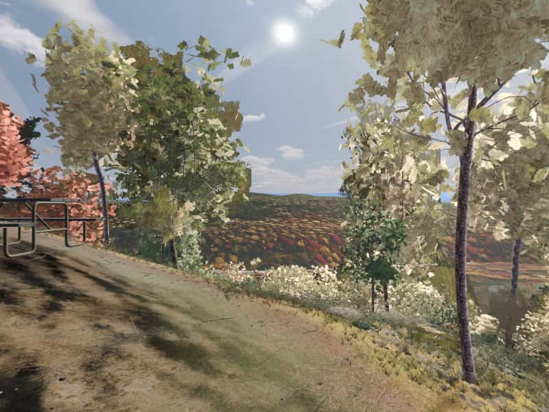
 Look around in 360
Campsite 65
688 ft southeast-facing hillside
Site 65 is one of the primitive, first-come campsites scattered through Green Ridge State Forest in western Maryland. It sits at 688 ft on a southeast-facing hillside, with running water 110 ft west. The drive in is rated “Rough road”.
- Booking
- None. Sites are first come, first served.
- Fee
- $10 a night for a standard site, $20 for a group site, paid at headquarters. Maryland DNR.
- Check in
- Sign the sheet at headquarters when you arrive, then go to the site.
- Is it free tonight?
- This page cannot know. The app shows what the sign-up sheet last showed, with the photo's age.
Hillside, by a creek, rough in, quiet.
- Modeled688 ft, southeast-facing hillside.
- ModeledRough road, 8.0 mi and 27 min from HQ, 3.9 mi of it unpaved, 15% grade on the way. The pitch sits 72 ft from the road.
- ModeledRunning water 112 ft west.
- ModeledOut of earshot of the range, the interstate and the freight line.
- CommunityA view.
- CommunityDescribed by campers, not yet photographed for Greenridge. Everything else here is modeled.
Modeled from USGS elevation, OpenStreetMap roads and the sun Community reported by campers
Hours of direct sun
The tallest ground on this site's horizon stands 18.3° above level, to the west.
On the March equinox direct sun reaches the pitch at 7:34 am and leaves it at 6:12 pm: 10 h 40 m of it, against 12 h 12 m of daylight on an open horizon.
| Date | First light | Last light | Direct sun | Open horizon |
|---|---|---|---|---|
| 20 March | 7:34 am | 6:12 pm | 10 h 40 m | 12 h 12 m |
| 21 June | 5:52 am | 7:08 pm | 13 h 18 m | 15 h 2 m |
| 21 December | 7:54 am | 4:00 pm | 8 h 8 m | 9 h 26 m |
The ground
The elevation model puts the pitch at 688 ft, on a hillside tilted about 26.1° to the southeast.
Within the 1.2 km square sampled around it, the site stands 227 ft above the lowest ground in that square, which lies 0.4 mi northeast and 379 ft below the high ground 0.5 mi northwest.
The nearest mapped water is an unnamed run 110 ft west. OpenStreetMap maps the channel but has no name for it. Treat any water from it before drinking.
Nearby sites
- Site 66 1918 ft away
Hollow, by a creek, rough in, quiet.
- Site 64 1.0 mi away
Flat shelf, by a creek, easy in, quiet.
- Site 63 1.2 mi away
Ridge-top, easy in, quiet.
- Site 54 1.6 mi away
Flat shelf, by a creek, easy in, quiet.
How to choose between them · All 100 sites
On these shortlists: Quiet · Beside water · Near a trail · All shortlists
How campers describe it
- Water nearby
- Views
Elevated overlook with Potomac River views. Steep drive in.
Field note from campers who have stayed here. Not an official description, and conditions change.
When the ridge takes the sun
- 20 MarchSun off the pitch at 6:12 pm, 76 minutes before sunset
- 21 JuneSun off the pitch at 7:08 pm, 1 h 40 m before sunset
- 22 OctoberSun off the pitch at 5:24 pm, 64 minutes before sunset
- 21 DecemberSun off the pitch at 4:00 pm, 56 minutes before sunset
For tonight, with the moon, darkness and the overnight low, open Site 65 in the app.
DNR has located and documented more than thirty family cemeteries inside the forest, many of their graves marked only by unlettered fieldstones.
More than thirty family cemeteries · 1800s–1974 · about 1.5 mi from this site, at Roby Cemetery
The families who farmed these ridges buried their dead close to home, and DNR has located and documented more than thirty cemeteries in the forest. The Brinkman-Rine Cemetery on Oldtown Orleans Road has 40 memorials on Find a Grave, with Brinkman, Rine, McCabe, Roby and Twigg among the names; the last burial is reported as Michael McCabe Sr. in 1974. A Methodist Episcopal church may once have stood nearby. Roby Cemetery, on Carroll Road in Roby Hollow, holds about 125 graves. The oldest dated stone reads 1855 and most are from the 1870s; many are fieldstones with no name or date. Its surveyors thought several families from around Green Ridge Station used it. At St. Patrick's in Little Orleans the graves go back to 1815, many of them unmarked graves of Irish canal workers. In 1994 the Baltimore Sun noted that names on the forest's tombstones, McCabe, McKnight and McKusker among them, were still in the local phone book. DNR asks descendants to visit and to coordinate any maintenance with the forest managers, and volunteers from Allegany County have cleared several of the cemeteries.
What is left to see: Brinkman-Rine is on the right of Oldtown Orleans Road at mile 19.2 of the DNR driving tour, about 50 feet into the woods. Roby Cemetery is on the north side of Carroll Road. Leave stones, fieldstones and grave goods exactly as found.
Sources (6)
- Maryland DNR, Green Ridge State Forest Driving Tour (PDF)
- Find a Grave, Brinkman-Rine Cemetery (40 memorials)
- MidAtlantic Daytrips, "Maryland's Beauty Spots" (family names at Brinkman-Rine; last burial 1974) — search summary
- Greg Tasker, "Footnotes to the nation's past: History of Green Ridge peoples forest setting", Baltimore Sun (11 Jul 1994)
- MHT survey AL-I-A-054, St. Patrick's Catholic Church, Little Orleans
- MHT survey AL-I-C-061, Roby Cemetery
Green Ridge had a railroad village with a hotel and about a dozen houses, and the orchard company's office across from the station was often taken for the station itself.
Green Ridge Station, the village that is gone · Early 1900s · about 1.5 mi from this site, at Roby Cemetery
Beside the Western Maryland line in the Paw Paw Bends stood a village the railroad men called Green Ridge. It grew up around the Merten family's apple-picking operations and the railway's own facilities: a bunkhouse, a waiting shed and the gear for maintaining the tunnel nearby. The surveyors of 1979 were told it had a hotel and about a dozen houses; the Baltimore Sun put it at 15 to 20 families. Orchards along the line shipped apples by train, and the railroad's history lists Green Ridge among the notably large ones. The Merten company's office, a two-story frame building on Merten Avenue, stood opposite the station and was often taken for it. Nearby, Joseph Higgins built a house in 1913 close to the canal, on one of the first poured-concrete foundations in the area, and his household could watch the boats until the canal closed in 1924. The surveyors of Roby Cemetery, in the next hollow, thought families from around the station likely buried their dead there. Bridge and building crews of the railway were still stationed at Green Ridge in camp cars in the late 1920s. When the village emptied is not recorded. The Merten office was being torn down in 1976, and by 1979 the hotel and houses were gone, leaving only foundations.
What is left to see: Nothing is marked. What is left of the village is protected as an archaeological site: leave it undisturbed. The Higgins houses are private.
Sources (5)
- HAER MD-175, Western Maryland Railway, Cumberland Extension, written historical and descriptive data (David A. Vago et al., NPS, 2010)
- MHT survey AL-I-C-060, Green Ridge Station (Preservation Associates, 1979)
- MHT survey AL-I-C-005, Merten's Office Building (Allegany County Historic Sites Survey, 1976)
- Greg Tasker, "Footnotes to the nation's past: History of Green Ridge peoples forest setting", Baltimore Sun (11 Jul 1994)
- MHT survey AL-I-C-009, Joe Higgins Canal House (via repo summary)
Provenance
Most of this page is computed from public data; the lines marked Community come from campers. The computed data was last rebuilt from its sources on 28 September 2026.
- Elevation, landform, slope, aspect, contours, the horizon profile and the steepest grade on the approach come from the USGS 3D Elevation Program (3DEP), read from its elevation tiles.
- Roads and watercourses come from OpenStreetMap contributors, licensed ODbL, as mapped at that rebuild. A road can wash out or close after it.
- Sun times are when the sun clears that measured skyline, computed with the NOAA Solar Calculator equations. They are for 2026 and shift by a minute or two from year to year.
- The pin comes from the Maryland Department of Natural Resources campsite GIS layer.
- Evenings here are the same sun times, on four dates of the year: when the sun drops behind this pitch's measured skyline, against the open-horizon sunset.
- What happened near here comes from published history: Maryland Historical Trust survey forms, Maryland DNR, the National Park Service and the C&O Canal's historians, and the records themselves. Each story lists its own sources; a story appears only when one of its catalogued places is within about two miles, and the distance is measured, not estimated. All the history sources.
- The modeled view and the 360 are rendered from a 3D model of the forest, from the pitch, through a whole day in each of five seasons. The ground is the same elevation data plus lidar. Tree heights come from lidar; the species mix and tree form come from US Forest Service inventory plots in Allegany County, so no tree here was surveyed individually. The tent, table and fire ring are the same stand-ins at every site. When a photograph from the site, ours or one a camper sends, shows the model is wrong about where the pitch is or what the ground is like, the model is corrected and the 360 is rendered again. How the 360 is made.
- Character tags and field notes come from campers. They are judgements rather than measurements.
- Availability is not on this page because nothing publishes it. The app shows what the last photograph of the sign-up sheet said, and how old that photograph is.
Greenridge is independent and is not affiliated with the Maryland Department of Natural Resources or any government agency. The forest's own rules apply.