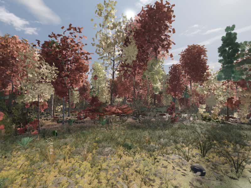
 Look around in 360
Campsite 67
1,101 ft flat shelf
Site 67 is one of the primitive, first-come campsites scattered through Green Ridge State Forest in western Maryland. It sits at 1,101 ft on a flat shelf, with running water 0.7 mi east. The drive in is rated “Gravel road”.
- Booking
- None. Sites are first come, first served.
- Fee
- $10 a night for a standard site, $20 for a group site, paid at headquarters. Maryland DNR.
- Check in
- Sign the sheet at headquarters when you arrive, then go to the site.
- Is it free tonight?
- This page cannot know. The app shows what the sign-up sheet last showed, with the photo's age.
Flat shelf, easy in, quiet, secluded.
- Modeled1,101 ft, flat shelf.
- ModeledGravel road, 5.9 mi and 20 min from HQ, 3.4 mi of it unpaved. The pitch sits 328 ft from the road.
- ModeledRunning water 0.7 mi east.
- ModeledOut of earshot of the range, the interstate and the freight line.
- CommunityRoom for a trailer, secluded.
- CommunityDescribed by campers, not yet photographed for Greenridge. Everything else here is modeled.
Modeled from USGS elevation, OpenStreetMap roads and the sun Community reported by campers
Hours of direct sun
The tallest ground on this site's horizon stands 14.3° above level, to the west.
On the March equinox direct sun reaches the pitch at 7:24 am and leaves it at 6:18 pm: 10 h 56 m of it, against 12 h 12 m of daylight on an open horizon.
| Date | First light | Last light | Direct sun | Open horizon |
|---|---|---|---|---|
| 20 March | 7:24 am | 6:18 pm | 10 h 56 m | 12 h 12 m |
| 21 June | 5:50 am | 7:18 pm | 13 h 30 m | 15 h 2 m |
| 21 December | 7:44 am | 4:08 pm | 8 h 26 m | 9 h 26 m |
The ground
The elevation model puts the pitch at 1,101 ft, on a flat shelf. At 2.7° the ground is level enough that it does not face anywhere in particular.
Within the 1.2 km square sampled around it, the site stands 264 ft above the lowest ground in that square, which lies 0.4 mi east and 617 ft below the high ground 0.5 mi northwest.
The nearest mapped water is an unnamed run 0.7 mi east. OpenStreetMap maps the channel but has no name for it. Treat any water from it before drinking.
Nearby sites
- Site 68 2393 ft away
Flat shelf, easy in, quiet.
- Site 62 0.6 mi away
Ridge-top, easy in, quiet.
- Site 89 0.7 mi away
Hillside, by a creek, rough in, quiet.
- Site 88 0.7 mi away
Hillside, by a creek, rough in, quiet.
How to choose between them · All 100 sites
On these shortlists: Quiet · Camper van · Phone signal · Secluded · All shortlists
How campers describe it
- Trailer-friendly
- Secluded
- Good cell service
Off Old Orleans Rd; secluded setting.
Field note from campers who have stayed here. Not an official description, and conditions change.
When the ridge takes the sun
- 20 MarchSun off the pitch at 6:18 pm, 70 minutes before sunset
- 21 JuneSun off the pitch at 7:18 pm, 1 h 30 m before sunset
- 22 OctoberSun off the pitch at 5:30 pm, 58 minutes before sunset
- 21 DecemberSun off the pitch at 4:08 pm, 48 minutes before sunset
For tonight, with the moon, darkness and the overnight low, open Site 67 in the app.
A 30-foot stone chimney in the woods is what DNR identifies as the last of an 1836 steam sawmill paid for by the estate of Charles Carroll of Carrollton.
The Carroll Chimney and the Town Hill company · 1820s–1870s · about 0.7 mi from this site, at Higgins Brick Ruins & Stone Chimney
Most of the forest's interior was patented from vacant land between 1820 and 1840, for timber and mining. Much of it was held in partnership by Richard Caton, who had married Charles Carroll of Carrollton's daughter Mary in 1787, and William Carroll, a grandson of Daniel Carroll of Rock Creek, a signer of the Articles of Confederation and the Constitution. Their Town Hill Mining, Manufacturing and Timber Company was financed by the estate of Charles Carroll of Carrollton, who had died in 1832, and in 1836 it built a steam sawmill. In 1841 John Upton published a report on "the Freehold Estate of William Carroll, Esq., at Town Hill" that promised "Inexhaustible Iron Mines"; a modern bibliography of the region's industry calls the ore imagined. In 1843 the London agents of Caton's daughter Marianne, Lady Wellesley, advertised a steam mill and 12,700 acres at Green Ridge. All DNR identifies from the mill is its chimney, a tapered stack of coursed native stone about 30 feet high, lined with brick, which the Youth Conservation Corps restored in 1974. A 1979 state survey recorded a stone chimney without naming Carroll and guessed at other uses; whether it is the same structure has not been settled. By about 1870 the land had passed to the Mertens family, whose orchard has its own chapter.
What is left to see: The Carroll Chimney stands alone in the woods. Ask at headquarters for directions, and leave it exactly as you find it.
Sources (9)
- Maryland DNR, Sustainable Forest Management Plan for Green Ridge State Forest (2019), §1.1, §2.4.3, §2.11–2.14, §3.2, §5.12, §9.2
- MHT survey AL-I-C-007, Higgins Brick Ruins & Stone Chimney (Preservation Associates, 1979)
- MHT survey AL-I-A-055, Green Ridge Camp CCC Headquarters Building, CCC Camp S-53 (Paula S. Reed & Edie Wallace, 2009; cites Mash, The Land of the Living)
- Maryland DNR, Green Ridge State Forest Driving Tour (PDF)
- John McGrain, Bibliography of Industry in Western Maryland (2005) — citations to Upton 1841, Davis & Vigers 1843, Cumberland Evening Times 1923, Niles' Register 1839
- Wikipedia, Charles Carroll of Carrollton (death 14 Nov 1832; daughter Mary m. Richard Caton; granddaughter Marianne Caton m. Marquess Wellesley)
- Wikipedia, Richard Caton (merchant) (1763–1845; m. Mary Carroll 25 Nov 1787)
- Wikipedia, Daniel Carroll (1730–1796; signed Articles and Constitution; died at home near Rock Creek)
- Greg Tasker, "Footnotes to the nation's past: History of Green Ridge peoples forest setting", Baltimore Sun (11 Jul 1994)
At what DNR calls Log Roll Overlook, logs were tipped off the edge of Green Ridge into Town Creek and floated nine miles at high water to a sawmill by the canal.
Logs, a narrow-gauge railroad and the Flintstone tanneries · 1830s–1914 · about 0.7 mi from this site, at Higgins Brick Ruins & Stone Chimney
Before the orchard, these ridges supplied timber and the Town Creek valley tanned leather. The Carroll interests built a steam sawmill in 1836. In the 1880s and 1890s a narrow-gauge logging line called the Green Ridge Railroad brought timber down from the north and passed it to the canal and the B&O over a wooden trestle across the Potomac at Okonoko; it was gone by 1904. The Kulp Lumber Company ran a sawmill east of Oldtown and shipped lumber from its own siding on the Western Maryland until 1914. At what DNR calls Log Roll Overlook, logs were tipped over the edge of Green Ridge into Town Creek and floated nine miles at high water to a sawmill by the canal. DNR's plan says the last of the virgin forest was cut between 1880 and 1912, and a period of neglect and wildfire followed. The Town Creek valley also tanned leather. Robert Lashley and his descendants ran a tannery at Flintstone that one history called the only industry in the eastern county other than farming and logging. Jason Hanks owned tanneries at Chaneysville, Gilpin and Everett and about 1865 had a fourteen-room house built near Gilpin. An 1880 directory lists two Flintstone tanners, L. T. Dickinson and J. B. Hoyt & Co.; which one owned the tannery whose manager's house stood near Gilpin is not known.
What is left to see: Log Roll Overlook on Green Ridge Road (driving tour mile 24.9) looks down on Town Creek. The tannery sites and houses near Flintstone and Gilpin are private or gone; nothing to visit.
Sources (7)
- HAER MD-175, Western Maryland Railway, Cumberland Extension, written historical and descriptive data (David A. Vago et al., NPS, 2010)
- Maryland DNR, Green Ridge State Forest Driving Tour (PDF)
- Maryland DNR, Sustainable Forest Management Plan for Green Ridge State Forest (2019), §1.1, §2.4.3, §2.11–2.14, §3.2, §5.12, §9.2
- MHT survey AL-II-A-117, Lashley Brick Farmhouse
- MHT survey AL-II-A-067, Ricker Frame House (built for tanner Jason Hanks)
- MHT survey AL-II-A-106, Tannery Manager's House, site
- MHT survey AL-I-A-055, Green Ridge Camp CCC Headquarters Building, CCC Camp S-53 (Paula S. Reed & Edie Wallace, 2009; cites Mash, The Land of the Living)
Provenance
Most of this page is computed from public data; the lines marked Community come from campers. The computed data was last rebuilt from its sources on 28 September 2026.
- Elevation, landform, slope, aspect, contours, the horizon profile and the steepest grade on the approach come from the USGS 3D Elevation Program (3DEP), read from its elevation tiles.
- Roads and watercourses come from OpenStreetMap contributors, licensed ODbL, as mapped at that rebuild. A road can wash out or close after it.
- Sun times are when the sun clears that measured skyline, computed with the NOAA Solar Calculator equations. They are for 2026 and shift by a minute or two from year to year.
- The pin comes from the Maryland Department of Natural Resources campsite GIS layer.
- Evenings here are the same sun times, on four dates of the year: when the sun drops behind this pitch's measured skyline, against the open-horizon sunset.
- What happened near here comes from published history: Maryland Historical Trust survey forms, Maryland DNR, the National Park Service and the C&O Canal's historians, and the records themselves. Each story lists its own sources; a story appears only when one of its catalogued places is within about two miles, and the distance is measured, not estimated. All the history sources.
- The modeled view and the 360 are rendered from a 3D model of the forest, from the pitch, through a whole day in each of five seasons. The ground is the same elevation data plus lidar. Tree heights come from lidar; the species mix and tree form come from US Forest Service inventory plots in Allegany County, so no tree here was surveyed individually. The tent, table and fire ring are the same stand-ins at every site. When a photograph from the site, ours or one a camper sends, shows the model is wrong about where the pitch is or what the ground is like, the model is corrected and the 360 is rendered again. How the 360 is made.
- Character tags and field notes come from campers. They are judgements rather than measurements.
- Availability is not on this page because nothing publishes it. The app shows what the last photograph of the sign-up sheet said, and how old that photograph is.
Greenridge is independent and is not affiliated with the Maryland Department of Natural Resources or any government agency. The forest's own rules apply.